Chaining on Sloping Ground | Guide to Surveying and Levelling

Chaining on Sloping Ground | Surveying and Levelling

There are two methods for determining horizontal distance on sloping ground.

  1. Direct Method
  2. Indirect Method

Direct Method of Chain Surveying

This method is also known as “Stepping Method”.

The horizontal distances are directly measured by the process of stepping.

Procedure

A path of chain or tape is stretched out from ‘P’.

The path length of chain or tape depends on the steepness of the ground.

The follower holds the zero end of the chain at ‘P’ and directs the leader at P1 to be in the line of PQ and stretch the chain or tape above the ground in horizontal line.

Direct Method | Chain Surveying

The leader then transfers the point ‘P1’ to P2 on the ground by means of plumb bob or dropping a pebble or an arrow,

Now the followers take the new position ‘P2’ and directs the leader to move forward and stretch the tape or chain in a line of PQ.

Now the followers take the new position ‘P2’ and directs the leader to move forward and stretch the tape or chain in a line of PQ and the new position is P3.

Again the leader transfers the point P3 to P4 on the ground as done earlier.

This process is repeated till the point Q is reached.

Horizontal distance PQ = S1 + S2 + S3 + S4 + S5

Read more

Classification of surveys according to their Purpose | Civil Engineering

Classification of  Surveys according to their Purpose

In our previous article, we discussed division and classification of surveys based on various factors such as Purpose, instruments, field of work, method of work etc.

In this article, we will discuss different types of surveys carried out for various purposes in the field of Surveying

Mine Survey

Mine survey involves exploration of mineral wealth in the country. This would include minerals such as Gold, copper, coal, silver etc. between the earth’s crust.

Mine Survey
Mine Survey

Geological Survey

Geological Survey is carried out by geologists. It is usually for the purpose of the study of earth’s rock structure. It helps to determine different strata in the earth’s crust.

Archaeological Survey

As the name suggests, Archaeological Survey is carried out by the Archaeologists for the purpose of their study concerning the past. This survey helps to trace the relics of the past.

Read more

Types of Scales in Engineering Surveying

Types of Scales | Engineering Surveying

In the previous article, we discussed briefly on the topic of “Scales in Surveying” where we came across an important term “Representative factor” which forms an important part in understanding the scales in Surveying.

In this article, we will discuss different types of scales used in Surveying…

The scales are classified into four categories:

  1. Plain Scale
  2. Diagonal Scale
  3. Vernier Scale
  4. Scale of chords

Lets go on with the discussion of types of scales briefly for our better understanding…

Plain Scale

Plain Scale is one on which it is possible to measure two dimensions only. For example, measurements such as units and lengths, metres and decimetres etc.

Plain Scale
Plain Scale

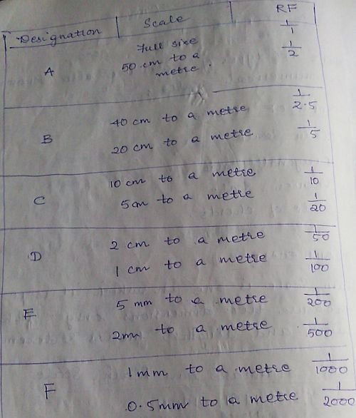
Six different plain scales in metric used by engineers, Architects and Surveyors.

Diagonal Scale

On diagonal scale, it is possible to measure three dimensions such as metres, decimetres and centimetres, units , tens and hundreds; yards, feet and inches etc.

A short length is divided into number of parts using the principle of similar triangle in which sides are proportional.

Read more

Methods of Calculation of Areas in Surveying | Simpson’s Rule

Calculation of Areas in Surveying | Simpson’s Rule

In one of my previous articles, I discussed Midpoint Ordinate Rule and Average Ordinate Rule in detail with an example and listed out various important methods used for the calculation of areas in Surveying. In this article, we will deal with the next important method (rule) i.e. Simpson’s Rule along with a numerical example used for the calculation of areas in the field of Surveying.

Here are the five important rules (Methods) used for the calculation of areas in Surveying:

  1. Midpoint ordinate rule
  2. Average ordinate rule
  3. Simpson’s rule
  4. Trapezoidal rule
  5. Graphical rule

Simpson’s Rule

Statement

It states that, sum of first and last ordinates has to be done. Add twice the sum of remaining odd ordinates and four times the sum of remaining even ordinates. Multiply to this total sum by 1/3rd of the common distance between the ordinates which gives the required area.

Where O1, O2, O3, …. On are the lengths of the ordinates

d = common distance

n = number of divisions

Note:

This rule is applicable only if ordinates are odd, i.e. even number of divisions.

If the number of ordinates are even, the area of last division maybe calculated separated and added to the result obtained by applying Simpson’s rule to two remaining ordinates.

Read more

Duties of a Surveyor in the field of Surveying | Civil Engineering

Role of a Surveyor | Surveying and Levelling

Surveying is a subject that is studied by Civil Engineers as well as Architects. Some Civil Engineers take up Surveying as their profession but otherwise, there are surveyors who have the expertise in the field of surveying.

They have certain important duties as a Surveyor to be carried out. In this article, we will briefly discuss their division of work and their duties towards the field of Surveying.

The work of a surveyor can be divided into four parts:

  1. Field work
  2. Computing
  3. Mapping
  4. Setting

Field work

Making and recording measurements in the field.

Computing

Making the necessary calculations to determine areas, location, volume etc.

Read more

Purpose of Surveying | Civil Engineering

Purpose of Surveying in the field of Civil Engineering

  • To determine the relative positions of the existing futures of the ground.
  • To layout our marked positions of proposed structures on the ground.
Surveying | Land Survey
  • To determine areas, volumes and other related quantities.
  • To prepare a map of a country of detailed out location of cities, towns, villages and major roads.
  • To prepare the engineering detailed plans and sections of various sections such as roads, railways, bridges, dams and other structure.
  • To prepare a topographical map showing details of hills, valleys and rivers.

Classification of Surveys according to their field of Work | Engineering Surveying

Classification of Surveys according to the field of work | Surveying and Levelling

In one of my previous articles regarding “Classification of Surveys“, discussion of various types of surveys have been listed out. We are now proceeding with the detail study of different types of surveys under the category of field of work.

The classification for the field of work is as follows:

Land Survey

This involved survey of objects in earth’s surface.

German Soldier carrying out Land Survey to determine the natural features and determine areas of strategic importance

Read more

Classification of Surveys according to the methods Employed in Surveying

Classification of Surveys according to the methods employed | Civil Engineering

In our previous articles, we discussed classification of Surveys according to their purpose in Surveying. Now we will go on with the discussion on classification of surveys according to the method of work.

Here are the two methods employed for Surveying:

  1. Triangulation Survey
  2. Transverse Survey

Triangulation Survey

The selected survey stations are connected with survey lines in such a way resulting in the formation of network of triangles. This survey is useful in surveying larger areas with uneven site boundaries.

The various formulas of the triangle are used to determine and area and various dimensions of the site.

Right angled triangle - (A = 1/2*base*height)

Transverse Survey

The whole area is divided into various transverses for the easy surveying. Since this method involves division of survey area into various transverse, it is termed as Transverse Survey.

A transverse is a geometrical figure consisting of more than three sides.

Classification of Surveys and Surveying Methods in Engineering

Classification of Survey

Study of classification of surveys is a major part of the study of Surveying as a whole. The surveys are conducted using various different instruments. The use of instruments depend upon its availability and suitability to the site.

Surveys are classified as following:

  1. According to the instruments used for the survey
  2. According to the purpose of the survey
  3. According to the method employed for the survey
  4. According to the field of work

In this article, we will list out the classification in each and category and study them in detail…

According to the instruments used

Chain Survey

Chain Survey is conducted using different lengths of chains specifically made for the surveying purpose.

Compass Survey

As the name itself suggests, the compass is used for the purpose of the survey.

Plane table Survey

Plane table is used for the purpose.

Levelling

Theodolite Survey

Theodolite is an instrument that is useful for conducting accurate surveys.

Read more

Introduction to Surveying | Civil Engineering

Surveying

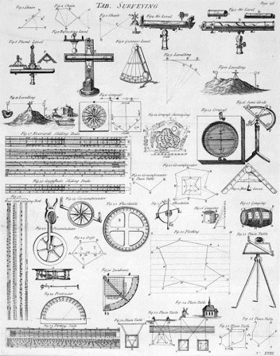
Surveying is the art of making suitable measurements in horizontal or vertical planes. This is one of the important subjects of civil engineering. Without taking a survey of the plot where the construction is to be carried out, the work cannot begin.

Surveying Chart
Surveying Chart

Levelling

Levelling is the art of representing relative positions in the vertical plane of different points on the earth’s surface.

It helps in determining the areas that are to be levelled to achieve a certain slope.

Principles of Surveying

All the surveys that are conducted are based on two fundamental principles. They are as follows:

  1. Working from whole to part
  2. Fixing a point with reference to two fixed points

Working from whole to part

In order to localize errors and prevent their accumulation, a set of control points is always established with great precision first for the whole area to be surveyed.

Later on, details or filled in between these control points to a relatively smaller precision.

This fundamental work principle is known as “Working from whole to part”.

Fixing a point with reference to two fixed points

Survey stations are fixed by atleast two measurements, either both linear or angular measurements or linear and angular measurements from two control points.

Read more